
This item is no longer available.
Handheld Satellite Communicators with GPS Navigation:
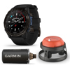
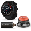
The Garmin inReach Explorer+ Satellite Communicator with Maps and Sensors is a rugged that enable two-way text messaging via 100% global Iridium satellite network (satellite subscription required). Trigger an interactive SOS to the 24/7 search and rescue monitoring center. Track and share your location with family and friends. Pair with compatible mobile devices using the free Earthmate app for access to downloadable maps (1), U.S. NOAA charts, color aerial imagery and more. inReach Explorer+ device adds preloaded DeLorme TOPO maps with on-screen GPS routing plus built-in digital compass, barometric altimeter and accelerometer.
You may venture off the grid, but you can still stay in touch - as long as you're carrying an inReach Explorer+. These handheld satellite communicators are designed for the outdoor enthusiast who wants to roam farther and experience more - without compromising their loved ones' peace of mind. From backcountry experiences to international adventures, inReach provides communication, location sharing, navigation and critical SOS functions for anyone who loves getting away from it all, on land, water or in the skies.
Explore Anywhere, Communicate Globally:
Using the worldwide coverage of the Iridium satellite network, these go-anywhere portable devices let you exchange text messages with any cell phone number or email address - while using GPS to track and share your journey's progress. You can also post to social media or even communicate inReach-to-inReach in the field. In case of an at-risk situation, you can also use inReach to trigger an SOS to the 24/7 monitoring center, text back and forth about the nature of your emergency, and receive confirmation when help is on the way.
No Cell Tower? No Phone Service? No Problem:
inReach Explorer+ give you all the tools to stay totally connected. You don't have to worry about being within range of a cell tower - or encountering spotty coverage in fringe zones or blackout areas. Your inReach communicator offers two-way messaging via the global Iridium satellite network.
Track and Share Your Whereabouts:
Turn on the tracking function of your inReach Explorer+ communicator, and let family and friends follow your progress on their computers or mobile devices, using the web-based MapShare portal. The inReach device will send waypoints at preselected time intervals, so followers can track your whereabouts online. You can also invite your crew back home to use MapShare to ping your inReach unit and see your GPS location, track your movements and exchange messages during your trip. You can even embed your MapShare page on a blog, website or social media.
Pair with Your Mobile Device:
For even more capability and convenience, the free Earthmate app syncs your inReach handheld via Bluetooth with your compatible Apple or Android device so you can access unlimited maps, aerial imagery and U.S. NOAA charts. Plus, Earthmate allows you to conveniently use all of the inReach features on your paired mobile device. For easier messaging, you can also access your phone's contact list from the Earthmate app to connect with fewer keystrokes.
Get Weather Wherever:
The optional inReach weather forecast service provides detailed updates directly to your inReach device, compatible smartphone or tablet paired with the Earthmate app, so you'll know what conditions to expect enroute. Basic and premium weather packages are offered. And you can request weather forecasts for your current location or any other waypoint or destination on your itinerary.
Who Will Answer Your SOS? Garmin IERCC Will:
The Garmin-powered International Emergency Response Coordination Center (IERCC) is the world leader in emergency response solutions and monitoring. They've supported rescues in more than 140 countries, saving many lives in the process. And they're standing by 24/7/365 to respond to your SOS, track your device and notify the proper contacts and emergency responders in your area. Then, while help is on the way, the IERCC will continue to text back and forth with you, providing updates and critical information until your situation is resolved. Battery Life: The internal, rechargeable lithium battery provides up to 100 hours of battery life at 10-minute tracking mode (default). Up to 75 hours at 10-minute tracking with 1-second logging. Up to 30 days at the 30-minute interval power save mode, and up to 3 years when powered off.
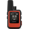
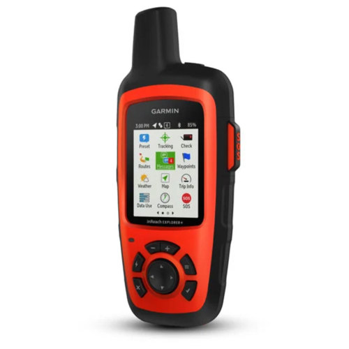
The Garmin inReach Explorer+ Satellite Communicator measures (W x H x D) 2.7 x 6.5 x 1.5" (6.8 x 16.4 x 3.8cm) with keypad and SOS door bump, its LED display measures (W x H) 1.4 x 1.9" (3.5 x 4.7cm) with a diagonal measurement of 2.31" (5.9cm) and weighs 7.5 oz (213g). The transflective color TFT LED display resolution is 200 x 265 pixels and the inReach Explorer+ Satellite Communicator has a 2 GB memory/history (user space varies based on included mapping) and its interface is a microSD card. This high sensitivity receiver unit is water-rated toIPX7 withstands incidental exposure to water of up to 3' (1m) for up to 30 minutes.
Preloaded Maps: The North America SKU of the inReach Explorer+ comes preloaded with a 1:24k map of Garmin Yarmouth (Former DeLorme) North America data of the U.S. and Canada. Mexico also is included at a 1:125k scale (derived from Garmin Yarmouth's Digital Atlas of the Earth). The inReach Explorer+ Satellite Communicator allows the ability to add maps and is equipped with Basemap. It includes detailed hydrographic feature (coastlines, lake/river shorelines, wetlands, and perennial and seasonal streams). It displays national, state and local parks, forests, and wilderness areas.
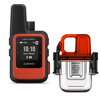
The units sensors include GPS, barometric altimeter, tilt-compensated 3-axis compass and GPS compass while moving. Daily smart feature for weather and the units inReach features include interactive SOS, send and receive text messages to SMS and email, send and receive messages to other inReach devices, exchange locations with other inReach devices, MapShare compatible with tracking, virtual keyboard for custom messaging, send waypoints to MapShare during a trip and send route selection to MapShare during a trip. Outdoor applications include compatibility with Earthmate and Garmin Explore website. Connectivity is wireless Bluetooth. Included with the inReach Explorer+ Satellite Communicator are a USB cable, carabiner clip, owner's manual and documentation.
(1) Preloaded DeLorme TOPO maps are not compatible with other Garmin devices. Other Garmin maps not compatible with this device.