Franko Maps Channel Islands Folded Map B402

SKU: BKSCDMFB402 MFR: B402
$12.95

Key Features

  • Explore the Channel Islands with our waterproof dive map, perfect for planning your dives!
  • Navigate confidently using detailed charts; this folded map is a must-have dive guide.
  • Durable & rip-resistant, this Channel Islands map survives any dive trip adventure.
  • Plan your underwater explorations using our map's marked dive sites and key locations.
  • Compact 4" x 7" folded size makes this Channel Islands dive map easy to carry on trips.
  • Benefit from expert cartography; a valuable resource for divers exploring Channel Islands.
See More Product Details
Calculate Shipping

See Options

1

Need help? Ask our experts.

Overview
Compare
Specs
Q&A

Questions & Answers

Reviews about this item

Review Summary

Franko Maps Channel Islands Folded Map B402 Specifications

  • Purpose

    Map Channel Islands

  • Map Sizes

    13" x 19" (33cm x 48.25cm)

  • Folded Size

    4" x 7" (10.2cm x 17.8cm)

  • Material

    Waterproof Rip-Resistant Synthetic

  • UPC Code

    852661262439

About Franko Maps Channel Islands Folded Map B402

Channel Islands:
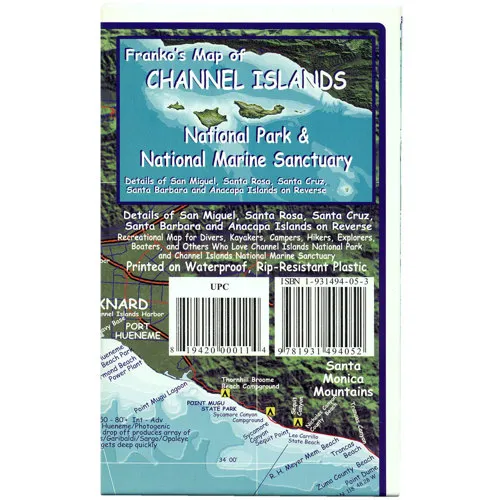
This colorful map gives you everything you need to know about the Channel Islands and the surrounding waters. This map is detailed with important facts about the islands and what you will find on land or under the water. Complete depth is depicted in descending hues of ocean blues to indicate actual ocean bathymetry and depth contours. Shaded relief accuracy is derived from USGS digital elevation models. Each dive spot is accurately described with what you will find when you dive the location, along with depth, recommended things to look for, and a detailed marine life guide.

Side 1 of this map of the Channel Islands shows the Santa Barbara-Ventura Coast with the five islands (San Miguel Island, Santa Rosa Island, Santa Cruz Island, Anacapa Island, and Santa Barbara Island). Side 2 of the map shows each of the Channel Islands individually. The map is printed on waterproof, rip-resistant plastic, making it perfect to take along on your dive. If you are planning a trip to the California Channel Islands this map is a must. The map measures 13" x 19" (33cm x 48.25cm) and folds to a handy 4" x 7" (10.2cm x 17.8cm).

Franko Maps Channel Islands Folded Map B402 Features

  • Franko Maps Channel Islands Folded Map:
  • Colorful Map: Gives Everything You Need to Know About the Channel Islands
  • Includes Information On-Surrounding Waters
  • Detailed w/Important Facts About Island & What You Will Find On-Land or Underwater
  • Complete Depths and Depth Contours
  • Shaded Relief Accuracy Derived from USGS Digital Elevation Models
  • Dive Sites Accurately Described: What You'll Find, Depth & Recommended Things to Look For
  • Side 1:
    Map of Channel Islands, Santa Barbara-Ventura Coast
    Five Islands; San Miguel, Santa Rosa, Santa Cruz, Anacapa, & Santa Barbara Island
  • Side 2:
    Shows Each Channel Islands Individually
  • Map Size: 13" x 19" (33cm x 48.25cm)
  • Folded Size: Handy 4" x 7" (10.2cm x 17.8cm)
  • Printed-On Waterproof Rip-Resistant Synthetic Material
  • Shaded Relief Topographic Map
  • Shows Dirt Roads, Dive Sites, Snorkel Sites, Moorings, Campground, Anchorages & More

Key Features

  • Explore the Channel Islands with our waterproof dive map, perfect for planning your dives!
  • Navigate confidently using detailed charts; this folded map is a must-have dive guide.
  • Durable & rip-resistant, this Channel Islands map survives any dive trip adventure.
  • Plan your underwater explorations using our map's marked dive sites and key locations.
  • Compact 4" x 7" folded size makes this Channel Islands dive map easy to carry on trips.
  • Benefit from expert cartography; a valuable resource for divers exploring Channel Islands.

What's in the box:

  • Franko Maps Channel Islands Folded Map