Search Results for “Frankos Santa Catalina Island Map” (2 Products)
Save 5% Every Day† with the Scuba.com Edge Card. Learn More
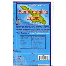
Franko Maps Santa Catalina Island Folded Map B401
SKU: BKSCDMFB401MFR: B401
- Explore Catalina Island with this detailed dive map.
- Waterproof dive map ensures lasting use in any condition.
- Expertly crafted map shows key dive and travel sites.
- Compact, folded map is perfect for dive bag storage.
- Up-to-date info on dive sites for safe exploration.
- Durable, rip-resistant map for reliable navigation.
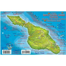
Franko Maps Santa Catalina Island Fish ID-Card
SKU: FRN23108MFR: 23108
(1)- Santa Catalina Island dive sites & mini-map included.
- Identify 70+ marine species with this Franko's Fish ID.
- Laminated plastic card is durable for diving use.
- Hole-punched for lanyard; keep your dive ID secure.
- Up-to-date info: Compass rose & points of interest.
- Essential dive guide: Catalina marine life identification.